Jarnioux 10,9 km

daniellebou
User
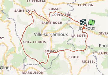

Length
10.9 km

Max alt
650 m

Uphill gradient
419 m
Km-Effort
16.5 km

Min alt
291 m

Downhill gradient
419 m
Boucle
Yes
Creation date :
2024-04-17 22:18:41.766
Updated on :
2024-04-17 22:18:43.225
3h45
Difficulty : Difficult

FREE GPS app for hiking
 SityTrail
IGN / Geographical institutes
SityTrail Plus
The world is yours!
About
Trail Walking of 10.9 km to be discovered at Auvergne-Rhône-Alpes, Rhône, Porte des Pierres Dorées. This trail is proposed by daniellebou.
Positioning
Country:
France
Region :
Auvergne-Rhône-Alpes
Department/Province :
Rhône
Municipality :
Porte des Pierres Dorées
Location:
Jarnioux
Start:(Dec)
Start:(UTM)
626287 ; 5091361 (31T) N.
Comments